There is a persistent need for improved tools and techniques to facilitate public involvement in transportation decision making.
Have a case study?
Submit your project »
Case Study Narratives
NJTPA Plan 2035

Creators: New Jersey Transportation Planning Authority
Creator Affiliation: FTA Public Transportation Participation (PTP) Pilot Grant Pro
Brief Description: The NJTPA developed a regional transportation plan for 2035 as required by federal law. Their public outreach process included the use of an interactive visioning tool in which users answered questions to evaluate priorities for future development and maintenance. NJTPA used the tool during visioning workshops. They engaged over 350 people at these workshops. A website dedicated to the RPA was also developed to share current information on the planning process.
Extended Description: The NJTPA began working on their Regional Transportation Plan(RTP) in the early summer of 2008 and was approved in August 2009. The NJTPA used a variety of methods to engage public participation. They set up an informative up to date website that included general information about the plan and public outreach sessions, an online survey, and an informative video. They hosted 15 visioning sessions that included the use of the interactive visioning tool developed by the NJTPA.
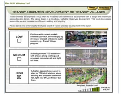
The visioning tool begins with the user selecting the county in which they live. They are then guided through a few informative slides about the future of the state. They are presented with three stories, each with different approaches for the future planning. These approaches include operations as usual, increased economic growth and decreased economic growth. The user has the ability to view details about each story and is then asked to choose one to continue. The impacts of the chosen story are then presented in a bar graph. It is easy to toggle between the other stories to compare results.
The tool continues with an informative guide on land use. The user selects between different types of land use and where they would like to see these types exist. Informative descriptions are given to educate the user while using the interactive tool. Based on your selections for the land use, the user can see how their choices positively or negatively affected the original story impacts.
The next section focuses on transportation strategies. Different types of infrastructure maintenance and improvements are rated. These combined with previous land use results yield a new impact graph. A detailed description of existing infrastructure conditions is displayed for educational purposes. The current funding is displayed using a pie chart and the funding based on your decisions is broken down. Additional funding options are presented as food for thought. Finally participants are given the opportunity to submit general feedback.
The NJTPA were able to engage over 350 people in their visioning workshops and 300 people on their online survey. This participation helped planners find out priorities among the citizens. The insights gained during the public outreach process were incorporated into the RTP Plan.
Time Frame: 1 year
Methods Used:
-
Visioning Workshops
-
Interactive Website
Tools Used:
-
Public Visioning Interactive Tool
-
Informative Video
Results: The NJTPA were able to engage hundreds of people in their outreach strategies and use insights from them to help guide the RTP.
Who to contact now: Jeffrey Perlman, jperlman@njtpa.org
Link to website: http://www.rtp2035.org/index.php

Reference:
-
NJTPA. (2008, October 15). Regional Transportation Plan 2035. Retrieved December 4, 2009, from


